About Wildfire Info
Disclaimer: This unofficial app does not represent any government agency and is not affiliated with any government agency. The sources of the data are the publicly accessible sources listed below. Browse current wildfire...
Disclaimer: This unofficial app does not represent any government agency and is not affiliated with any government agency. The sources of the data are the publicly accessible sources listed below.
Browse current wildfire and prescribed burn activity throughout all of the world.
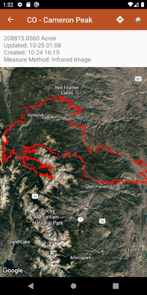
Active Wildfire Perimeter data from WFIGS updated every 20 minutes. Tagged by state, search by name, and filter by acres burned. WFIGS stands for the Wildland Fire Interagency Geospatial Services (WFIGS) Group
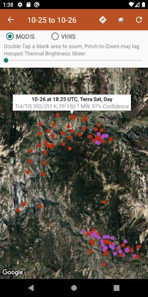
NASA MODIS and VIIRS satellite instruments data: Thermal hotspot maps by region show wildfire activity in the past 48 hours. See hotspot info including fire radiance power, brightness temperature, and confidence.
Air Quality data (PM 2.5, PM10, and Ozone) globally from EPA AirNow and PurpleAir.
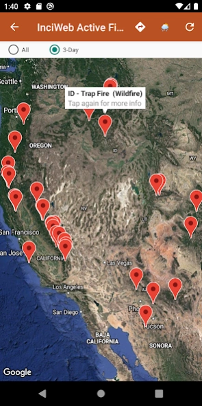
InciWeb & CAL FIRE active fire maps: hot-link to the corresponding official incident webpage.
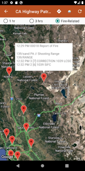
CHP (California Highway Patrol): Incidents in the past 3 hours related to fires are filtered out separately, all traffic incidents are included viewable by last 1 or 3 hours.
Links to current hyper-local weather summary conditions from NWS, NOAA, Government of Canada, and Government of Australia: including temperature, wind and gust conditions, and local forecasts anywhere in the USA, Canada, or Australia at your centered map location.
Wildfire Situation Reports section with mirrored PDFs from NIFC and more.
Pull up the Google Maps app for an area with the embedded deep links.
There is a section for wildfire-related US government Twitter accounts viewable by map by approximate location or sorted into national and state sources in a table view.
Information is posted as soon as it becomes available from WFIGS, NIFC, NASA, InciWeb, CAL FIRE, CHP, NOAA, NWS, Government of Canada, and Government of Australia.
Previous Versions
Here you can find the changelog of Wildfire Info since it was posted on our website on 2019-07-17 18:10:59.
The latest version is 3.0 and it was updated on 2024-04-22 11:55:26. See below the changes in each version.
Wildfire Info version 3.0
Updated At: 2022-05-12
Changes: - Fix for crash when navigating throughout the app on poor network conditions or if navigating too quickly
- Additional fix for crash when loading maps due to map load race condition
- Fix for crash when tapping Map Tools popup on InciWeb Map view
- Removed duplicate Map Tools crosshair for WFIGS perimeters, and prevented this from potentially happening on other screens
- News section removed for now, being re-worked and may be re-introduced in the near future in a different way
Wildfire Info version 2.8
Updated At: 2022-05-06
Changes: - Fix for crash when loading maps due to race condition
- Fix for crash when tapping Map Tools popup on WFIGS view.
- Map Tools crosshair now slews for WFIGS perimeters
- Clustered markers for country/continent MODIS/VIIRS hotspots for usability/speed improvement
- InciWeb Articles Feed removed because it went defunct
- Ozone Air Quality map now correctly remembers your last viewed location
- Maps now remember your chosen Map Type correctly across all screens
- General code cleanup
Wildfire Info version 2.7
Updated At: 2021-10-14
Changes: - Air Quality maps from EPA AirNow: PM2.5, PM10, and Ozone.
- Added specific maps for US states, Canadian provinces, Australian territories, and major countries when viewing MODIS & VIIRS hotspot maps or PM2.5/PM10 air quality maps.
- Canadian & Australian weather added throughout app when applicable.
- Fix for blue map crosshairs causing a crash when the callout explanatory bubble was tapped on.
Wildfire Info version 2.6
Updated At: 2021-07-13
Changes: - Fix for Recent Wildfire News links erroring out when clicked.
- Added a NESDIS GOES 16/17 Satellite Animations quick links section.
Wildfire Info version 2.4
Updated At: 2021-06-25
Changes: - Added WFIGS details to all WFIGS/IRWIN Active Fire Perimeters. Access through the new "Details" button on any WFIGS/IRWIN perimeter.
- IRWIN Fire Perimeters is back online in this app. It is now labeled as WFIGS/IRWIN Active Fire Perimeters.
- Re-ordered the main menu, WFIGS/IRWIN back to the top. Better grouping throughout.
Wildfire Info version 2.3
Updated At: 2021-06-14
Changes: - Improved developer contact info section
- Improved help section access throughout the app
- Improved news sources description in the Recent Wildfire News section
- Year tag added to the IRWIN data
Wildfire Info version 2.2
Updated At: 2021-06-06
Changes: - Fix for a crash when tapping on some news stories from the Current Wildfire News map
- Fix for a crash when tapping on an IRWIN perimeter
- Navigational fixes in the Wildfire-Related Twitter Tables
- More updates coming soon
Wildfire Info version 2.1
Updated At: 2020-10-26
Changes: - IRWIN perimeters completely redesigned. Major memory and speed optimizations, perimeters should now be smooth to view when zooming and scrolling, especially for larger fires.
- New IRWIN fires tables: All and 3-Day. Searchable by name and filter by acres burned.
- New CAL FIRE fires tables: All and 3-Day. Searchable by name
- Redesigned Twitter map & table sections with many new sources
- Bug fixes
Wildfire Info version 2.0
Updated At: 2020-09-29
Changes: - 3 day filter for CAL FIRE Active Fires Map, InciWeb Active Fires Map, and the InciWeb Incidents Feed.
- Search filter for Current Wildfire News Wire, InciWeb Articles Feed, and the InciWeb Incidents Feed.
- Maps now locally cache their last zoomed/panned position for easier access to the information you need
- Bug fixes
Wildfire Info version 1.9
Updated At: 2020-09-11
Changes: - Get directions to the center of any map with the ↱ icon in the top-right.
- Improved MODIS/VIIRS hotspot metadata. Brightness is now broken down into Ti4 and Ti5 brightness. Also included is Confidence level, which satellite took the data (Terra or Aqua), and whether the data was taken during the Day or Night.
Disclaimer
Official Google Play Link
We do not host Wildfire Info on our servers. We did not scan it for viruses, adware, spyware or other type of malware. This app is hosted by Google and passed their terms and conditions to be listed there. We recommend caution when installing it.
The Google Play link for Wildfire Info is provided to you by apps112.com without any warranties, representations or guarantees of any kind, so access it at your own risk.
If you have questions regarding this particular app contact the publisher directly. For questions about the functionalities of apps112.com contact us.